
Synthetic-aperture radar
Form of radar used to create images of landscapes
Synthetic-aperture radar ▸ Facts ▸ Comments ▸ News ▸ Videos
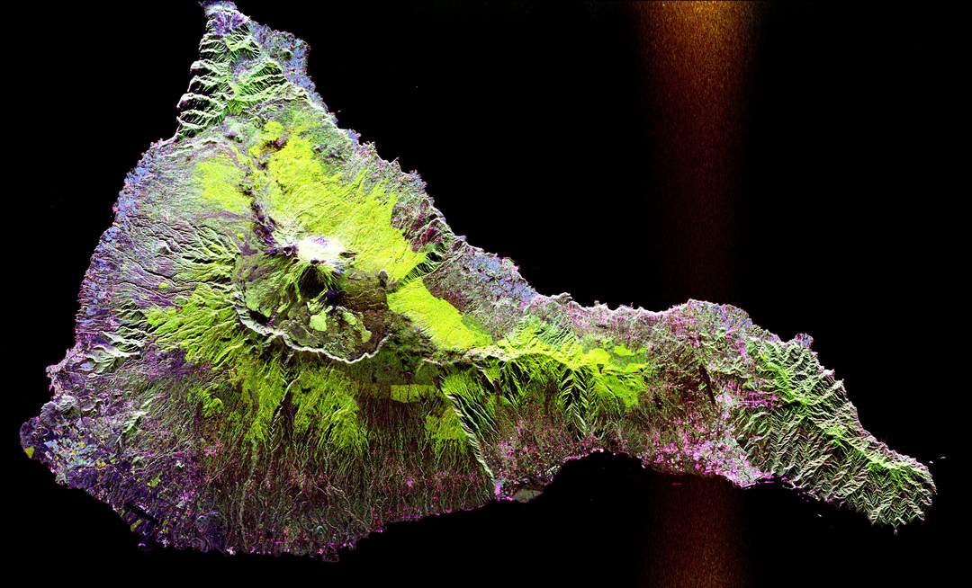
Synthetic-aperture radar (SAR) is a form of radar that is used to create two-dimensional images or three-dimensional reconstructions of objects, such as landscapes. SAR uses the motion of the radar antenna over a target region to provide finer spatial resolution than conventional stationary beam-scanning radars. SAR is typically mounted on a moving platform, such as an aircraft or spacecraft, and has its origins in an advanced form of side looking airborne radar (SLAR). The distance the SAR device travels over a target during the period when the target scene is illuminated creates the large synthetic antenna aperture. Typically, the larger the aperture, the higher the image resolution will be, regardless of whether the aperture is physical or synthetic – this allows SAR to create high-resolution images with comparatively small physical antennas. For a fixed antenna size and orientation, objects which are further away remain illuminated longer – therefore SAR has the property of creating larger synthetic apertures for more distant objects, which results in a consistent spatial resolution over a range of viewing distances.
| 0 shares | ShareTweetSavePostSend |
You Might Like
Countdown begins for NISAR – NASA ISRO Synthetic Aperture Radar MissionNISAR mission’s primary objectives are to study land & ice deformation, land ecosystems, and oceanic regions in areas of common interest to the US and Indian science communities.IndiaTimes - Published | |
TOI explains: How Nisar was built - why it’ll take 90 days before any data comes inThe Nasa-Isro Synthetic Aperture Radar (Nisar) satellite is scheduled to launch on July 30 aboard the GSLV-F16 rocket from Sriharikota. Following launch, a meticulous deployment sequence will unfold..IndiaTimes - Published | |
Bengaluru space firm tests payload in extreme cold conditions in spaceSpace startup GalaxEye successfully tested its SyncFusion Imaging System in the extreme environment of the South Atlantic Anomaly. The system merges Synthetic Aperture Radar and optical imagery,..IndiaTimes - Published | |
Nasa chief to visit Isro centre testing NISAR today; Says 'Space unites'NASA administrator Bill Nelson emphasized the longstanding trend of space serving as a unifying force, bringing together even countries with adversarial relations for decades. He expressed the..IndiaTimes - Published | |
NISAR testing gains pace, Isro looks at 2 launches in November-DecemberThe Isro is planning to launch at least two more missions this year, including the in-orbit Servicer Mission and the Lunar sample return mission. These missions are part of India's ambitions to..IndiaTimes - Published | |
Nisar will aid understand forests & wetlands better: JPLThe Nasa-Isro Synthetic Aperture Radar (Nisar) satellite, set to launch in 2024, will provide researchers with unprecedented insight into Earth's forests and wetlands. The mission aims to understand..IndiaTimes - Published | |
Isro releases image of Chandrayaan-3 lander taken by Chandrayaan-2's orbiterThe Indian Space Research Organisation (Isro) on Saturday released a new image of the Chandrayaan-3 lander Vikram taken by an instrument onboard the Chandrayaan-2 orbitor."Here is an image of the..IndiaTimes - Published | |
Space startup unveils UAV-based high-res SAR systemGalaxEye, a SpaceTech start-up, on Tuesday unveiled its high-resolution aerial UAV-based Synthetic Aperture Radar (SAR) System that can perform exceptionally detailed and high resolution all-weather..IndiaTimes - Published | |
Nisar lands in Bengaluru on US C-17 aircraftThe US Consulate, Chennai, on Tuesday said the NASA-Isro Synthetic Aperture Radar (Nisar) landed in Bengaluru on a US Air Force C-17 aircraft from NASA-JPL in California, setting the stage for final..IndiaTimes - Published |