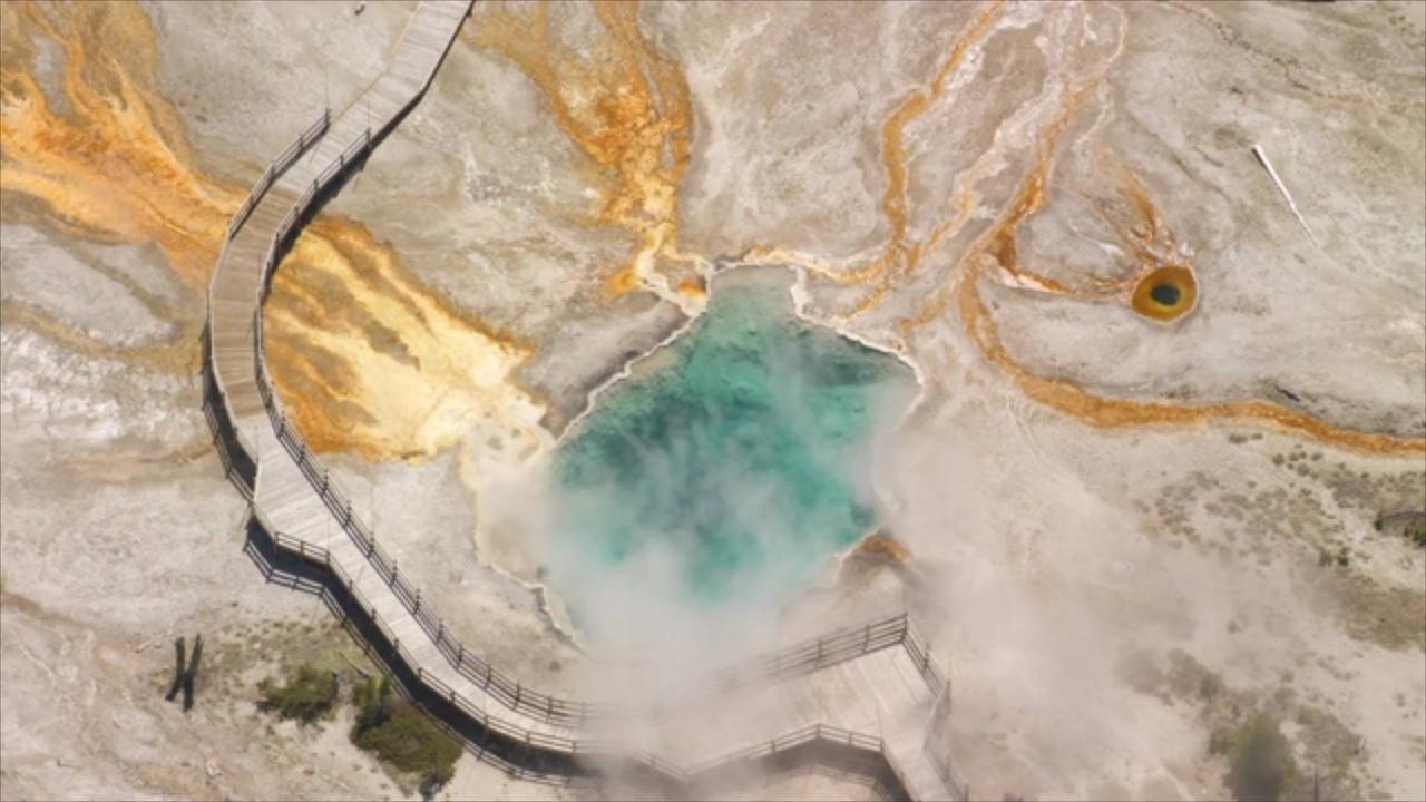
CBS reports that new data has
revealed "geological hazards"
underneath Yellowstone National Park.
.
A team of scientists used lidar technology to shed light on
prehistoric landslides and massive earthquakes that may have
permanently impacted the potentially dangerous geologic area.
Advanced geological surface mapping gave
geologists the clearest view to date of Paradise
Valley and a northern portion of Yellowstone.
.
Lidar, short for "light detection and ranging,"
is used to survey large areas of land with
a sensor usually mounted on an airplane.
Geologists have an intense interest in
the area, as Yellowstone National Park
sits atop a known volcanic hotspot.
However, Michael Poland, a geophysicist with the
U.S. Geological Survey, says that the chance of
a volcanic eruption "is very unlikely in our lifetimes.".
Poland added that studying the area remains crucial
due to the likelihood of damaging earthquakes and
hydrothermal explosions in the foreseeable future.
.
Yann Gavillot, a geologist with the Geohazards Program at
Montana Bureau of Mines and Geology, wrote about the
lidar data in a weekly column by the U.S. Geological Survey.
Gavillot said the work could , "significantly improve hazards maps by allowing
better characterization of the location, geometry,
and activity of known faults and landslides.".
CBS reports that the same technology
helped geologists uncover active faults along
the edges of Yellowstone in August of 2022
A powerful magnitude 6.7 earthquake struck near Indonesia’s Pulau Pulau Tanimbar region at a depth of 49.6 miles, causing strong tremors but fortunately no tsunami threat. The earthquake was recorded late at night, sending residents scrambling from their homes. Despite the strong seismic shock, early assessments indicate minimal structural damage and no immediate reports of casualties. Indonesian authorities, along with global seismic monitors, continue to evaluate the aftershock potential and regional impact. Indonesia lies along the volatile “Ring of Fire” and frequently experiences seismic events of varying magnitudes. Emergency response teams remain on alert as aftershocks are possible. The US Geological Survey has classified the quake as moderate but deep, which likely reduced surface-level devastation. While the region breathes a sigh of relief over the lack of a tsunami, experts warn of potential tremors in the coming hours. Local officials urge residents to remain cautious but calm.
#IndonesiaEarthquake #TanimbarIslands #SeismicActivity #NoTsunami #EarthquakeUpdate #NaturalDisaster #RingOfFire #BreakingNews #IndonesiaNews #PulauPulauTanimbar #USGS #GeologicalAlert #EarthquakeToday #AftershocksPossible #TremorAlert #SeismicZone #EmergencyResponse #StaySafeIndonesia #GeologicalNews #DisasterPreparedness
Also Read
Earthquake in Delhi-NCR: 3.7 Magnitude Quake Jolts Jhajjar, Tremors Felt Across Haryana :: https://www.oneindia.com/india/4-1-magnitude-earthquake-in-delhi-ncr-quake-jolts-jhajjar-tremors-felt-across-haryana-7798445.html?ref=DMDesc
Delhi Earthquake: Netizens Flood Social Media With Memes :: https://www.oneindia.com/new-delhi/delhi-earthquake-netizens-flood-social-media-with-funny-memes-7796679.html?ref=DMDesc
Earthquake Tremors Felt In Delhi And NCR; Eyewitnesses Share Their 'Scary' Experience :: https://www.oneindia.com/new-delhi/earthquake-tremors-felt-in-delhi-ncr-7796657.html?ref=DMDesc
According to data from the US Geological Survey, Delhi has not recorded an earthquake above magnitude 5 in the last 10 years. It experienced a 4.1 magnitude.. DNA
A powerful 6.5 magnitude earthquake struck Colombia’s capital Bogota on Sunday, June 8, 2025, causing widespread panic as buildings trembled and residents ran for safety. Originating at a depth of 10 km, the quake hit 170 km from Bogota at 9:08 am local time. The tremors coincided with a national tragedy as presidential candidate Miguel Uribe Turbay was shot at a campaign event the same day. He was seen bleeding from the head and back in videos. Colombia now reels from a double crisis—natural disaster and political violence.
#ColombiaEarthquake #BogotaEarthquake #EarthquakeToday #MiguelUribeTurbay #ColombiaNews #BreakingNews #Bogota #ColombianPolitics #SeismicZone #6Point5Magnitude #GFZ #USGS #PresidentialCandidateShot #ColombiaElection2025 #CampaignAttack #TerrorInBogota #EarthquakeHorror #EmergencyInColombia #QuakeAndChaos #June82025
Also Read
Ryo Tatsuki’s Earthquake Warning: The New Baba Vanga Whose Predictions Are Shaking the World :: https://www.oneindia.com/international/ryo-tatsuki-earthquake-warning-the-new-baba-vanga-whose-predictions-are-shaking-the-world-4159403.html?ref=DMDesc
Earthquake In Pakistan: National Center for Seismology Reports 4.2 Magnitude Tremors :: https://www.oneindia.com/international/earthquake-in-pakistan-national-center-for-seismology-reports-4-2-magnitude-tremors-4143877.html?ref=DMDesc
Powerful 7.3 Magnitude Earthquake Strikes Argentina Near Ushuaia :: https://www.oneindia.com/international/powerful-7-3-magnitude-earthquake-strikes-argentina-near-ushuaia-4141681.html?ref=DMDesc
~HT.336~
A powerful 6.0 magnitude earthquake struck near Crete early Thursday, shaking areas across Greece, Israel, Egypt, and Cyprus. The quake, at a depth of 69 km, was centered north of Crete, near Ágios Nikólaos and Irákleion. Residents reported intense, brief tremors. This seismic event follows a similar 6.0 quake in the Mediterranean last week. Situated on a major tectonic boundary, Greece remains highly quake-prone, with thousands of tremors recorded recently in the Cyclades region alone.
#CreteEarthquake #GreeceQuake #EarthquakeNews #SeismicActivity #MediterraneanQuake #USGS #EMSC #Crete #AegeanIslands #Earthquake2025 #NaturalDisaster #TectonicPlates #Cyclades #Seismology #BreakingNews #GlobalNews #GeologyAlert #EarthquakeUpdate #GreeceNews #EmergencyAlert #CreteNews #EarthTremor #DisasterPreparedness #HellenicArc #Aftershocks #GeologicalEvent #DisasterNews
Also Read
Five Migrants Confirmed Dead as Coast Guard Conducts Multiple Rescue Operations Off Greece :: https://www.oneindia.com/international/migrants-rescue-operations-greece-coast-guard-011-4016059.html?ref=DMDesc
Diasporas Of Greece-India: Promising Area Of Collaboration :: https://www.oneindia.com/international/diasporas-of-greece-india-promising-area-of-collaboration-4009333.html?ref=DMDesc
UN Refugee Agency Voices Concern Over Rising Fatalities from Migrant Shipwrecks in Greece :: https://www.oneindia.com/international/un-refugee-agency-concern-fatal-migrant-shipwrecks-greece-011-4002191.html?ref=DMDesc
~HT.318~ED.102~
Astronauts from Poland, Hungary and India head back to Earth ending first ISS mission
It was Axiom's fourth station trip since 2022. The Houston company's clientele includes the wealthy as well as countries seeking representation in space.
READ MORE : http://www.euronews.com/2025/07/14/astronauts-from-poland-hungary-and-india-head-back-to-earth-ending-first-iss-mission
Subscribe to our channel. Euronews is available on Dailymotion in 12 languages
Credit: euronews (in English) Duration: 01:36Published
'A loss of balance': Korek Bojanowski explores abuse of power in Polish film schools
It's no understatement to say Korek Bojanowski is the pride of Poland. His coming-of-age story, 'A Loss of Balance' has touched a nerve that's echoed far and wide. It was also Poland's choice to screen his debut feature in Brussels at the close the country's presidency of the European Union.
READ MORE : http://www.euronews.com/2025/07/13/a-loss-of-balance-korek-bojanowski-explores-abuse-of-power-in-polish-film-schools
Spark your senses, wake your wonder. Euronews Culture seeks to show creativity in action and inspire our audience to explore the world through the five senses. Start your journey through the best of Europe's arts, gastronomy, traditions and high-end craftsmanship.
Credit: euronews (in English) Duration: 03:55Published
Amidst turmoil in Manipur, John Khammuanlal Gwite achieved a historic feat in Poland's 'Race Around Poland', finishing in under 10 days. This accomplishment.. IndiaTimes
A shocking new report by CNN claims that US Defense Secretary Pete Hegseth ordered a pause on crucial weapons shipments to Ukraine without informing the White House. When questioned about the decision, President Donald Trump appeared to be unaware, denying responsibility by stating, “I don’t know, why don’t you tell me?” This unilateral action by the Pentagon chief has reportedly set off a major scramble within the administration, highlighting a severe breakdown in communication. The pause comes at a perilous moment for Kyiv, as Russia has intensified its missile attacks across Ukraine. Such a disruption in the supply of munitions could have devastating consequences on the battlefield. The lack of coordination was so profound that key figures like Secretary of State Marco Rubio and Special Envoy Keith Kellogg allegedly learned of the aid suspension from press reports, not from the Pentagon or Hegseth himself. Sources cited by CNN suggest that Hegseth's lack of a chief of staff or senior advisers has led to this poor interagency coordination.
In an attempt to control the narrative, the Pentagon stated the pause was for an assessment of US stockpiles, while the White House clarified that this review was never intended to halt the flow of aid. Following the backlash, President Trump reportedly ordered the resumption of some arms shipments, including Patriot missiles stationed in Poland. This entire incident raises serious questions about the chain of command, policy clarity, and the stability of US support for Ukraine.
#Trump
#Ukraine
#Hegseth
#WhiteHouse
#Pentagon
#BreakingNews
#WorldNews
#UkraineWar
#OneindiaNews
#USAid
#USWeapons
#Zelensky
#UkraineWar #UkraineAid
Also Read
US President Donald Trump Announces 25% Tariffs On Japan, South Korea :: https://www.oneindia.com/international/us-president-donald-trump-announces-25-tariffs-on-japan-south-korea-7794333.html?ref=DMDesc
Trump Calls Musk’s America Party Plan ‘Ridiculous’ And ‘Unworkable’ :: https://www.oneindia.com/international/trump-calls-musk-s-america-party-plan-ridiculous-and-unworkable-7793443.html?ref=DMDesc
America Will Be Richer, Safer, and Prouder: Trump As Big, Beautiful Bill Passes Congress :: https://www.oneindia.com/international/trump-s-big-beautiful-bill-passes-congress-in-big-win-for-us-president-011-7790919.html?ref=DMDesc


![Indonesia Earthquake: MASSIVE 6.7 Tremor Strikes Tanimbar Islands | No Tsunami Alert Issued [Video]](https://video.newsserve.net/300/v/20250714/1416420348-Indonesia-Earthquake-MASSIVE-Tremor-Strikes-Tanimbar.jpg)
![6.5 Magnitude Earthquake ROCKS Colombia as Sirens Blare in Bogota | Prez. Candidate Shot Same Day [Video]](https://video.newsserve.net/300/v/20250608/1413307286-Magnitude-Earthquake-ROCKS-Colombia-as-Sirens.jpg)
![Greece Earthquake Breaking: Powerful 6.0 magnitude quake strikes | Tsunami alert issued [Video]](https://video.newsserve.net/300/v/20250522/1411508612-Greece-Earthquake-Breaking-Powerful-magnitude-quake.jpg)

![Astronauts from Poland, Hungary and India head back to Earth ending first ISS mission [Video]](https://video.newsserve.net/300/v/20250714/1416476234-Astronauts-from-Poland-Hungary-and-India-head-back.jpg)
!['A loss of balance': Korek Bojanowski explores abuse of power in Polish film schools [Video]](https://video.newsserve.net/300/v/20250713/1415933646-loss-of-balance-Korek-Bojanowski-explores.jpg)
![Trump’s OWN Cabinet IGNORES Him: Defense Sec. Hegseth FREEZES Ukraine Weapons Without Telling Trump [Video]](https://video.newsserve.net/300/v/20250709/1415930024-Trump-OWN-Cabinet-IGNORES-Him-Defense-Sec.jpg)
![Worries for future of EU's Schengen areaas Poland reinstates border checks [Video]](https://video.newsserve.net/300/v/20250708/1415835098-Worries-for-future-of-EU-Schengen-areaas.jpg)