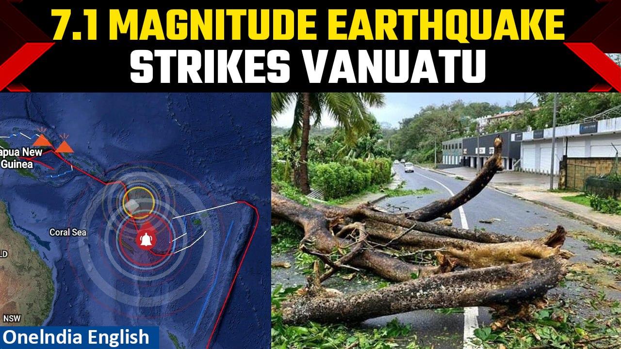
Vanuatu Earthquake: 7.1 magnitude quake strikes south of Vanuatu, tsunami warning lifted | Oneindia
Video Credit: Oneindia - Duration: 01:32s - Published
Vanuatu Earthquake: 7.1 magnitude quake strikes south of Vanuatu, tsunami warning lifted | Oneindia
A 7.1 magnitude quake struck south of Vanuatu on Thursday, the United States Geological Survey said, triggering a tsunami warning.
USGS initially reported a magnitude of 7.3 and a depth of 35 kilometres, but soon revised its report.
The offshore quake hit at 1256 GMT at a depth of 48 kilometres (30 miles), about 123 kilometres south of the town of Isangel and 338 kilometres from the capital Port Vila, USGS said.
A massive 7.4 magnitude earthquake struck the coastal region near the Argentina-Chile border on Thursday, triggering widespread alarm and a tsunami warning for parts of the South Pacific. According to the U.S. Geological Survey, the quake’s epicenter was located offshore at a shallow depth, amplifying its impact across coastal towns.
#ChileEarthquake #ArgentinaEarthquake #EarthquakeToday #TsunamiWarning #ArgentinaChileQuake #7.4Magnitude #ChileTsunamiAlert #BreakingEarthquake #SeismicActivity #EarthquakeSwarm #ArgentinaChileTremor #EarthquakeUpdate #NaturalDisaster #QuakeNews #SouthAmericaQuake
Also Read
Powerful 7.3 Magnitude Earthquake Strikes Argentina Near Ushuaia :: https://www.oneindia.com/international/powerful-7-3-magnitude-earthquake-strikes-argentina-near-ushuaia-4141681.html?ref=DMDesc
Earthquake In Pakistan: Tremors Of Magnitude 4.4 Recorded On Richter Scale :: https://www.oneindia.com/international/earthquake-in-pakistan-tremors-of-magnitude-4-4-recorded-on-richter-scale-4140009.html?ref=DMDesc
Earthquake Of Magnitude 5.9 Strikes Afghanistan-Tajikistan Border, Tremors Felt In India And Pakistan :: https://www.oneindia.com/international/earthquake-of-magnitude-5-9-strikes-afghanistan-tajikistan-border-tremors-felt-in-india-and-pakista-4128147.html?ref=DMDesc
~PR.152~HT.408~GR.124~PR.282~
A 5.5-magnitude earthquake hit central Myanmar near Meiktila on Sunday, marking one of the strongest aftershocks since the deadly March 28 temblor that killed over 3,600. The quake struck as the country entered its Thingyan holiday, compounding a humanitarian crisis worsened by the earlier 7.7 quake and ongoing civil war. No casualties have been reported so far, but minor damage and panic were reported in Wundwin township. Relief efforts continue amid growing fears of food shortages, health risks, and political suppression of information in quake-hit zones.
#MyanmarEarthquake #Meiktila #EarthquakeNews #Aftershock #NaturalDisaster #ThingyanHoliday #DisasterRelief #MandalayQuake #SeismicActivity #USGS #HumanitarianCrisis #CivilWar #Naypyitaw #AsiaEarthquake #BreakingNews #UNRelief #GlobalNews #MyanmarToday #Wundwin #March28Quake
~HT.318~ED.102~
Indonesia grappled with seismic upheaval as two impactful earthquakes struck on New Year's Eve. The first, a 6.3 magnitude, hit Papua, initially measured at 39 km depth but initially recorded as 6.2 at..
December 27: Earthquake rattled Japan's Kuril Islands, leaving residents shaken and authorities on high alert. The National Centre for Seismology (NCS) reported that the earthquake measured 6.3 on the..


![Argentina-Chine Earthquake BREAKING: 7.4 Magnitude Quake Strikes Coast, Tsunami Warning Issued [Video]](https://video.newsserve.net/300/v/20250502/1409713828-Argentina-Chine-Earthquake-BREAKING-Magnitude-Quake.jpg)
![Myanmar Rattled Again: 5.5 Quake Strikes Near Meiktila Weeks After Deadly 7.7 Earthquake | Watch [Video]](https://video.newsserve.net/300/v/20250413/1407936980-Myanmar-Rattled-Again-Quake-Strikes-Near.jpg)
![Indonesia Struck by Two Powerful Earthquakes, No Casualties Reported Amid Intensity| Oneindia News [Video]](https://video.newsserve.net/300/v/20231231/1362955779-Indonesia-Struck-by-Two-Powerful-Earthquakes-No-Casualties.jpg)
![Japan Earthquake: 6.3 magnitude quake hits Kuril Islands; USGS reports 2 tremors | Oneindia News [Video]](https://video.newsserve.net/300/v/20231228/1362817249-Japan-Earthquake-magnitude-quake-hits-Kuril.jpg)
![China Earthquake: Toll Climbs in Quake Tragedy, Rescuers Battle Harsh Conditions| Oneindia News [Video]](https://video.newsserve.net/300/v/20231220/1362461371-China-Earthquake-Toll-Climbs-in-Quake-Tragedy-Rescuers.jpg)