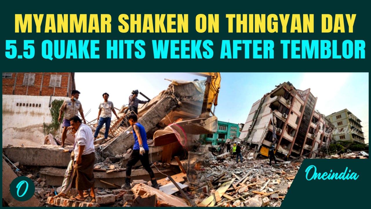
Myanmar Rattled Again: 5.5 Quake Strikes Near Meiktila Weeks After Deadly 7.7 Earthquake | Watch
Video Credit: Oneindia - Duration: 03:30s - Published
Myanmar Rattled Again: 5.5 Quake Strikes Near Meiktila Weeks After Deadly 7.7 Earthquake | Watch
A 5.5-magnitude earthquake hit central Myanmar near Meiktila on Sunday, marking one of the strongest aftershocks since the deadly March 28 temblor that killed over 3,600.
The quake struck as the country entered its Thingyan holiday, compounding a humanitarian crisis worsened by the earlier 7.7 quake and ongoing civil war.
No casualties have been reported so far, but minor damage and panic were reported in Wundwin township.
Relief efforts continue amid growing fears of food shortages, health risks, and political suppression of information in quake-hit zones.
The Indian Army has denied claims made by ULFA-I of a cross-border drone strike on its Myanmar headquarters that allegedly killed 19 cadres. Defence PRO Mahendra Rawat said the Army has no inputs confirming any such operation. Sources suggest the attack may stem from infighting among militant groups. ULFA-I leader Paresh Baruah remains elusive near the tri-junction with ISI support. With Myanmar’s border regions in turmoil, Indian officials remain concerned over insurgent activity and the exploitation of the porous border.
#ULFAI #IndianArmy #MyanmarStrike #DroneStrikeDenial #IndiaMyanmarBorder #CrossBorderAttack #BreakingNews #ManipurMilitancy #PareshBaruah #InsurgentGroups #Tatmadaw #MyanmarConflict #BorderSecurity #IndiaNews #ULFAClaims #Infighting #ISI #NorthEastIndia #PorousBorders #SecurityAlert #ULFACamps #MilitantActivity #RupomAsom #MyanmarViolence #CounterTerror #DefencePRO #ArunodayDohotiya #NayanMedhi #IndiaDeniesStrike
Also Read
Operation Sindoor Reveals Multi-Front Threat: India's Strategic Wake-Up Call from Pakistan, China, and Turkey :: https://www.oneindia.com/india/operation-sindoor-reveals-multi-front-threat-indias-strategic-wake-up-call-from-pakistan-china-a-7793223.html?ref=DMDesc
China Uses Pakistan As ‘Live Lab’ For Weapons Testing, Says Indian Army Deputy Chief :: https://www.oneindia.com/india/lt-gen-rahul-r-singh-81-of-pakistan-s-military-gear-comes-from-china-7791183.html?ref=DMDesc
First Greenfield Shipyard, HSL, Turns 85! Marks Naval Milestone Amidst Infrastructure Leap, Financial Revival :: https://www.oneindia.com/india/indias-oldest-shipyard-hsl-turns-85-marks-naval-milestone-amidst-infrastructure-leap-and-financ-7786319.html?ref=DMDesc
Hawaii’s Kīlauea volcano erupted again early Wednesday morning, unleashing a spectacular 300-foot lava fountain in its 30th eruption in under a year. The U.S. Geological Survey’s Hawaiian Volcano Observatory (HVO) confirmed that “vigorous fountaining” erupted from the Halemaʻumaʻu crater around 1:20 a.m. local time. Lava spewed from the north vent, reaching between 150 and 300 feet, while USGS live cameras captured the molten display from multiple angles. An orange aviation alert has been issued due to the eruption, but nearby airports remain unaffected.
Since December 23, 2024, Kīlauea’s eruptive cycle has continued with brief, dramatic episodes. The National Weather Service warned that volcanic gas and ash could drift south, potentially impacting nearby communities. Despite the awe-inspiring natural show, scientists caution that these eruptions can be unpredictable and potentially hazardous. Kīlauea remains one of Earth’s most active volcanoes-and it’s showing no signs of slowing down.
#Kilauea #HawaiiVolcano #LavaFountain #VolcanoEruption #KilaueaEruption #USGS #HalemaumauCrater #HVO #HawaiiNews #VolcanoWatch #Kilauea2025 #NaturePower #GeologyNews #LavaLive #VolcanoAlert #EarthScience #ExtremeNature #HawaiiTravelAlert #LavaFlow #LiveEruption
~HT.318~ED.346~GR.122~
A massive earthquake measuring 7.0 on the Richter scale struck Russia’s Kuril Islands on Sunday, sending tremors across the Pacific Rim but sparking no tsunami warnings. The quake, initially pegged at 6.35 magnitude by the German Research Center for Geosciences, was later upgraded by both the US Geological Survey and the Pacific Tsunami Warning Center.
Fortunately, no tsunami alerts were issued, calming fears of a wider Pacific disaster. The quake's epicenter lay off Russia’s remote eastern coast, a region often rocked by seismic activity due to tectonic collisions along the Pacific Ring of Fire. There were no immediate reports of damage or casualties, but authorities are closely monitoring the region for aftershocks. The Kuril Islands, located between Russia and Japan, have been a long-standing hotspot for both geological tension and geopolitical friction. Experts advise residents to stay alert and follow official updates in case of aftershocks.
#RussiaEarthquake #KurilIslands #TsunamiAlert #RingOfFire #SeismicActivity #EarthquakeUpdate #BreakingNews #PacificQuake #GeologicalNews #NaturalDisaster #EarthquakeSafety #NoTsunamiThreat #RussianFarEast #QuakeToday #KurilQuake #Magnitude7 #USGS #DisasterPreparedness #JapanRussiaZone #SeismicZone
A rare earthquake struck the New York–New Jersey region late Saturday night, sparking online panic and raising fresh concerns over seismic preparedness in one of the most densely populated parts of the U.S. The 3.0 magnitude tremor hit six miles beneath Hasbrouck Heights, New Jersey, at 10:18 PM, according to the United States Geological Survey (USGS). Residents across Bergen, Morris, Essex Counties, and New York City felt the ground shake.
Social media exploded with reactions—some users shared personal experiences, while others posted shaky videos and memes comparing the quake to recent disasters like the tsunami-triggering quake in Russia. NYC Emergency Management confirmed the event and issued precautionary guidelines, warning citizens about possible aftershocks. No damages or casualties have been reported so far, but many are still rattled by the unusual seismic activity. Authorities continue to monitor the situation closely as updates roll in.
#NewYorkEarthquake #NewJerseyTremor #HasbrouckHeights #NYCquake #EarthquakeNews #USGSEarthquake #QuakeAlert #SeismicShock #Earthquake2025 #NYCUpdates #NaturalDisaster #TremorNYC #AftershockWarning #NYCEmergency #BergenQuake #EastCoastEarthquake #USQuakeZone #FeltInNYC #NoDamageReported #BreakingNews
~HT.410~ED.102~GR.125~
Kamchatka Earthquake Tsunami alert has been issued after a massive 8.8 magnitude quake struck off Russia’s far eastern Kamchatka Peninsula. The USGS confirmed that the Kamchatka Earthquake Tsunami originated from a shallow depth of 19.3 km, just 125 km southeast of Petropavlovsk. This region near Avacha Bay is now the epicenter of global concern as destructive waves are expected to reach coastal areas of Russia and Japan within hours. The Kamchatka Earthquake Tsunami has triggered international monitoring, putting vast stretches of the Pacific coastline on red alert.
#KamchatkaEarthquakeTsunami
#PacificTsunamiAlert
#RussiaEarthquake
#8point8Quake
#JapanTsunamiWarning
~PR.274~GR.125~ED.103~HT.318~
A powerful 7.3‑magnitude earthquake struck off Alaska’s coast Wednesday, prompting an immediate tsunami warning for South Alaska and the Alaska Peninsula. The USGS reported its epicenter was roughly 54 miles south of Sand Point at a shallow 20 km depth — conditions that raise tsunami fears. The National Tsunami Warning Center confirmed a tsunami has occurred, cautioning coastal communities from Kennedy Entrance to Unimak Pass.
Though only these regions are at risk, residents are urged to evacuate low-lying areas and stay alert for updates. Alaska, part of the seismic Pacific Ring of Fire, previously endured a deadly 9.2 quake in 1964—the strongest in North America, which unleashed a devastating tsunami. While a 7.2 quake in July 2023 passed without major incident, the current event has revived emergency vigilance. Authorities are working to assess impacts and ensure community safety as aftershocks and swelling waves remain a concern.
TAGS
#AlaskaEarthquake #TsunamiWarning #RingOfFire #USGS #PacificQuake #SeismicAlert #NaturalDisaster #SandPoint #AlaskaPeninsula #CoastalSafety #Earthquake2025 #TsunamiThreat #EmergencyAlert #Geology #EarthquakeDepth #AftershockWatch #USAlert #DisasterPrep #AlaskaNews #QuakeWarning
~HT.318~ED.102~GR.122~
A powerful 6.2 magnitude earthquake struck near Istanbul, Turkey, sending shockwaves across the Sea of Marmara and triggering widespread panic. The quake, which hit in the early hours, was felt..
Turkey Earthquake: A powerful 6.2 magnitude earthquake struck the Sea of Marmara near Silivri, Istanbul, on April 23, 2025, at 12:49 PM local time. The tremor, occurring at a shallow depth of..
A series of four earthquakes struck India, Myanmar, and Tajikistan within just one hour on Sunday morning, alarming millions across central and South Asia. The strongest tremor, at magnitude 6.1, hit..


![Indian Army REFUTES ULFA Claims | No strikes on Banned outfit ULFA Camps in Myanmar [Video]](https://video.newsserve.net/300/v/20250713/1416373114-Indian-Army-REFUTES-ULFA-Claims-No-strikes.jpg)

![Kilauea 30th Eruption: Volcano Produces 1000-Foot Lava Fountain | Tourists, Locals On High Alert [Video]](https://video.newsserve.net/300/v/20250807/1418841450-Kilauea-30th-Eruption-Volcano-Produces-1000-Foot-Lava.jpg)
![BREAKING: Powerful 7.0 Earthquake Strikes Russia's Kuril Islands | Tsunami Panic Grips After Quake [Video]](https://video.newsserve.net/300/v/20250803/1418458378-BREAKING-Powerful-Earthquake-Strikes-Russia.jpg)
![Panic & Chaos As Earthquake Rattles NYC And New Jersey | 3.0 Tremor Strikes Near Hasbrouck Heights [Video]](https://video.newsserve.net/300/v/20250803/1418448032-Panic-Chaos-As-Earthquake-Rattles-NYC-And.jpg)
![Earthquake, Tsunami in Kamchatka: Pacific Coasts on Alert After 8.8 Quake| Details [Video]](https://video.newsserve.net/300/v/20250730/1418033202-Earthquake-Tsunami-in-Kamchatka-Pacific-Coasts-on-Alert.jpg)
![Sirens BLAZE As 7.3-Magnitude Quake Strikes Alaska, MAJOR Tsunami Warning Issued | U.S News [Video]](https://video.newsserve.net/300/v/20250717/1416738102-Sirens-BLAZE-As-Magnitude-Quake-Strikes.jpg)
![Turkey Earthquake: Chilling Video Shows Moment 6.2 Magnitude Quake Hit Istanbul, Turkey | Watch [Video]](https://video.newsserve.net/300/v/20250423/1408870380-Turkey-Earthquake-Chilling-Video-Shows-Moment.jpg)
![Turkey Earthquake BREAKING: Magnitude 6.2 Quake Shakes Turkey, Watch People Run in Panic | VIDEO [Video]](https://video.newsserve.net/300/v/20250423/1408866218-Turkey-Earthquake-BREAKING-Magnitude-Quake-Shakes.jpg)
![4 Earthquakes Rock Asia in 1 Hour | India, Myanmar & Tajikistan Hit Back-to-Back | Aftershocks [Video]](https://video.newsserve.net/300/v/20250413/1407970160-Earthquakes-Rock-Asia-in-Hour.jpg)