
Geographic information system
System to capture, manage, and present geographic data
Geographic information system ▸ Facts ▸ Comments ▸ News ▸ Videos
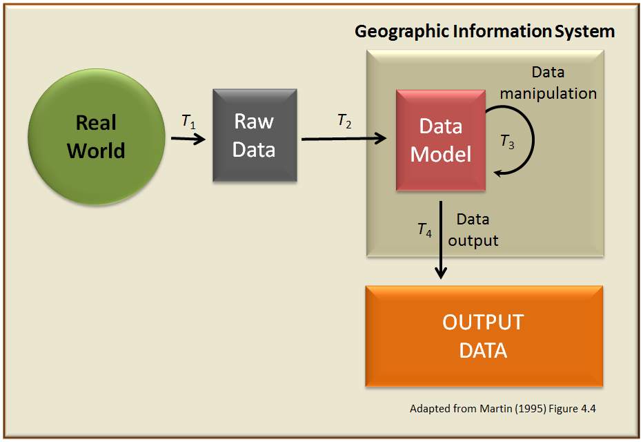
A geographic information system (GIS) consists of integrated computer hardware and software that store, manage, analyze, edit, output, and visualize geographic data. Much of this often happens within a spatial database; however, this is not essential to meet the definition of a GIS. In a broader sense, one may consider such a system also to include human users and support staff, procedures and workflows, the body of knowledge of relevant concepts and methods, and institutional organizations.
| 0 shares | ShareTweetSavePostSend |
You Might Like
Digital Aadhaar shields Kashmir’s Chinars from axe of greedChinar trees in Kashmir now have unique numbers under the 'Digital Tree Aadhaar' initiative. This helps in real-time tracking and monitoring using GIS and QR codes. Over 28,560 trees have been..IndiaTimes - Published | |
Invest in heart of India: Madhya Pradesh CM pitch before GISMadhya Pradesh CM Mohan Yadav presented the state's industry-friendly policies at the Global Investors Summit curtain-raiser in Bhopal. He highlighted affordable land and significant incentives for..IndiaTimes - Published | |
Indian think-tank, GIS leader join hands to train students in geospatial technologyIndian public policy think-tank, Centre for Knowledge Sovereignty, and GIS solutions leader, Esri India, have partnered to launch the 'master mentors geo-enabling Indian scholars' (MMGEIS) program. The..IndiaTimes - Published | |
App with live heatmaps to help reduce road fatalitiesAt a recently-held meeting of the NCR Planning Board on road safety and trauma care, the road transport ministry gave details of eDAR and how the central and state government agencies such as police,..IndiaTimes - Published | |
Andhra Pradesh inks MoUs for Rs 13 lakh crore during 2-day GISAndhra Pradesh entered into 352 memoranda of understanding (MoUs) with various organisations to execute projects worth Rs 13.05 lakh crore during the two-day Global Investors Summit (GIS), which..IndiaTimes - Published | |
Andhra Pradesh eyes 6 lakh new jobs as investors pledge Rs 13 lakh crore during mega 2-day summitAndhra Pradesh has received investment proposals for big-ticket projects worth a whopping Rs 13 lakh crore during the two-day Global Investors Summit (GIS) that kick-started on Friday.Chief minister Y..IndiaTimes - Published | |
Mukesh Ambani says UP's ‘swarnim yug’ has begun, to invest Rs 75K cr in state‘UP Plus Yogi Bahut Hai Upyogi,’ KM Birla Quotes PM’s Viral Speech At GISIndiaTimes - Published | |
UP has projected itself as developing state in last 6 years, getting huge investments, now, says Yogi AdityanathFive days before UP is to host a Global Investors Summit, CM Yogi Adityanath says that this is the first time investments are coming to all 75 districts. In an interview with TOI, he is confident that..IndiaTimes - Published |